

Three months into the ceasefire, Israel deepens its hold on Gaza and levels neighborhoods
Gaza: Changes that occurred during the ceasefire October 2025-January 2026
Yarden Michaeli writes in Haaretz on 15 January 2026:
Three months since the announcement of the cease-fire between Israel and Hamas, satellite images reveal significant developments on the ground across the Gaza Strip.
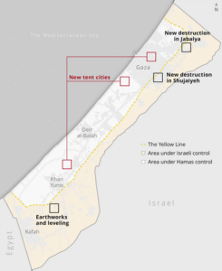
These include the entrenchment of the Israel Defense Forces along the border of its area of control in the Strip. This border – known as the Yellow Line – in some cases extends hundreds of meters into territory that is officially supposed to be under Hamas control. The images also show zones of destruction that have expanded since the cease-fire began, including in the Jabalya area and the Shujaiyeh neighborhood, both within and beyond the area under IDF control.
In Hamas-controlled territory, new tent cities have been established to house tens of thousands of displaced Gazans.
All these developments are taking place while the Strip remains in a state of limbo – following only partial implementation of U.S. President Donald Trump’s plan to end the war in Gaza – and as gunfire, airstrikes and clashes continue to occur regularly. The official cessation of hostilities in October and the release of the hostages from Hamas captivity were intended as a transitional phase toward full implementation of the Trump deal, which promised, among other things, to regulate the withdrawal of the IDF from most of Gaza, the enclave’s reconstruction, the provision of relief to the masses of displaced Gazans and the disarmament of Hamas.
Some of these steps have indeed taken place: the living hostages and all but one of the bodies of the dead have been returned to Israel, the IDF has partially withdrawn its forces, and the Strip is now divided along a line of control – the Yellow Line. However, the parties have yet to move to the next stage of the agreement, and the interim situation is dragging on. On Wednesday, U.S. envoy Steve Witkoff announced the commencement of the plan’s next stage, while Prime Minister Benjamin Netanyahu said it is only a symbolic step.
The Israeli army controls about 54 percent of Gaza’s territory. Here, the division of control in the Strip and some of the areas of activity documented by satellite can be seen:
The latest satellite images were taken by Planet Labs. An examination of the images shows that after the deal went into effect, the IDF reorganized its forces and deployed them, among other places, along the Yellow Line, which Chief-of-Staff Eyal Zamir recently defined as “Israel’s new border.” As part of this move, the IDF established new outposts in the areas under its control.
According to the British organization Forensic Architecture, since the cease-fire began and as of mid-December, the IDF has established 13 new outposts inside the Strip. These include two large outposts in the Jabalya area. The outposts are tall, prominent in the landscape, and provide a wide field of view. Their construction involved demolishing buildings and clearing land, as well as the use of heavy engineering equipment to build high earthworks from which all of northern Gaza can be observed. Palestinians have posted videos online showing these outposts.
The satellite images also show that since the cease-fire, the IDF has continued to demolish hundreds of additional buildings in Jabalya, around the Indonesian Hospital. Most of the destruction is on the Israeli side of the Yellow Line, as it appears in the IDF’s official publications – but it is clear that many more buildings have been destroyed west of the line as well.
Ground-level video footage shows the considerable height of the new outposts in Jabalya. One such video was published by Kan 11.
The new outpost in Jabalya. Kan 11
The yellow line area is a constant flashpoint for incidents including gunfire and fatalities, according to official IDF statements and Palestinian testimonies. Since the cease-fire’s announcement, a total of 449 Palestinians have been killed in various locations in the Strip and another 1,246 have been wounded, according to the Palestinian Health Ministry, which does not distinguish between civilians and combatants in its reports. According to UNICEF, 100 of the dead are children.
In one incident, two children, aged 10 and 12, who according to their family were searching for firewood, were killed in an airstrike. The IDF later said it had targeted two suspects who crossed the Yellow Line and acted “to remove the threat.” Since the cease-fire, three IDF soldiers have been killed in the southern Strip by anti-tank fire and snipers from Hamas.
The line itself is not continuously marked on the ground – the IDF has placed large yellow concrete barriers, sometimes hundreds of meters apart, to indicate its route. Palestinians have testified that the IDF occasionally moves the barriers westward, into territory under Hamas control. Analysis of the satellite images shows that in various areas along the Yellow Line, there is indeed a gap between the location of the yellow barriers on the ground and the position of the Yellow Line as marked in the army’s official publications, including the map published by the IDF Spokesperson’s Unit in Arabic for the Gaza population.
For example, in the Shujaiyeh neighborhood in eastern Gaza City: The yellow concrete barriers can be identified in the satellite images, located about 300 meters west of the official Yellow Line shown on the IDF map. International media outlets have identified additional locations where the official publications do not match the reality on the ground. As Haaretz revealed a month ago, since the cease-fire the IDF has continued to demolish hundreds more buildings in Shujaiyeh, west of the official line, up to the line of the yellow barriers.
The IDF said in response: “In accordance with the cease-fire framework, IDF operations are carried out to address threats from terrorist organizations in Gaza, headed by Hamas, which have repeatedly violated the cease-fire. The IDF is working to mark the Yellow Line visually, in line with ground conditions and the updated operational assessment, and is conducting necessary operational activities in the area while making efforts to minimize harm to civilians as much as possible and in accordance with international law.”
The army did not answer specific questions, such as why the location of the blocks on the ground is not updated on the official map, why the line is not marked continuously on the ground in a way that could reduce civilian harm, and why destruction of buildings is expanding – even beyond the Yellow Line, in areas under Hamas control.
The destruction that took place in recent months adds to the erasure of entire cities in the Strip during the war. According to the latest report from the United Nations Satellite Center, which measured the extent of destruction in the Strip up to mid-October, more than 80 percent of the structures in the Strip were destroyed or damaged during the war.
The direct result of the widespread destruction is a massive displacement crisis that Gazans are suffering from acutely. According to the UN, hundreds of thousands of people are struggling to survive in tents damaged by rain, wind and seawater, or in buildings at risk of collapse. In total, 1.3 million people are in need of assistance. In the past few days alone, thousands of tents and makeshift shelters housing tens of thousands of people have been destroyed or damaged by rain and strong winds.
Recently, Haaretz reported that doctors in the Strip have identified a rise in illness and hospitalization, attributed in part to prolonged living in damp tents. The Palestinian Health Ministry said that seven people have died from cold since the beginning of winter, and that 25 more Gazans have been killed by collapsing buildings.
New tent cities along the Netzarim Corridor (in central Gaza) and in northern Gaza. Credit: Planet Labs PBC / Video from the Egyptian Committee’s Instagram account
Against this backdrop, satellite images obtained by Haaretz show that in Hamas-controlled territory, at least four large tent cities have been set up in recent weeks – two in the central Strip, near the Netzarim Corridor that bisects the Strip, and two more in northern Gaza City.
According to the Egyptian Committee, a body involved in providing aid in the Strip, the tent city near the Netzarim Corridor is intended to house 15,000 families. As part of the effort to assist the displaced, UN agencies have also cleared and leveled land in the Hamad neighborhood of Khan Yunis, establishing a tent city there to move some of the displaced away from the harsh conditions on the coast. Despite these efforts, massive resources will be required to assist the displaced masses who have been living in tents for two years now.
As part of the transition to phase two of the Gaza deal, a residential area for Gazans not affiliated with Hamas is supposed to be established in territory under Israeli control. Satellite images published by Haaretz last week showed earthworks, clearing and leveling near Rafah in an area the army says is intended for this purpose. The earthworks, which began about a month ago, cover one square kilometer. Military sources said that in the initial stage, the area will house 20,000 Gazans.
However, for the time being, it is unclear if and when the parties will actually move forward to the next stage.
This article is reproduced in its entirety