
To their meetings with right-wing lawmakers in the Knesset, the Yesha officials have been coming equipped with a blown-up map showing what they claim is the Palestinian state envisioned by the Trump plan in red. The map highlights the 15 settlements that would become isolated enclaves encircled by the Palestinian state and also shows that many of the key highways running into and through the West Bank, such as routes 5 and 60, would no longer be accessible to Israeli drivers.

Settler leaders produce map they claim shows Trump plan for Palestinian state
May 27, 2020
In effort to thwart deal, West Bank mayors lobby right-wing MKs with blown-up map showing proposal’s 15 envisioned enclave settlements surrounded by large red Palestinian state
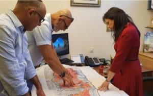
Yesha Council director and chair, Yigal Dilmoni, & David Elhayani with MK Ayelet Shaked and West Bank map based on the Trump plan, 25 May 2020
Jacob Magid reports in The Times of Israel:
Settler leaders have been meeting with right-wing lawmakers over the past week and presenting them with what they claim is a map of the Palestinian state envisioned by the Trump plan, which would encircle 15 Israeli communities in a manner they say is unacceptable.
The Yesha umbrella council of West Bank mayors passed a resolution earlier this month declaring that it would not accept the Trump plan’s green-lighting of Israeli annexation of parts of the West Bank if it meant agreeing to the other key part of the proposal — the establishment of a Palestinian state.
In the weeks since, Yesha officials, including chairman David Elhayani, director Yigal Dilmoni and various West Bank mayors, have been sitting down with lawmakers from the Likud, Jewish Home and Yamina parties in an effort to convince them to oppose the Trump plan, for which Prime Minister Benjamin Netanyahu has voiced his support.