

Gaza: we analysed a year of satellite images to map the scale of agricultural destruction
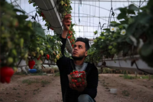
Growing strawberries in Beit Lahia, Gaza, back in 2020. Every greenhouse in Beit Lahia has since been destroyed.
Lina Eklund, He Yin and Jamon Van Den Hoek write in The Conversation on 6 February 2025:
The ceasefire agreed between Israel and Hamas makes provisions for the passage of food and humanitarian aid into Gaza. This support is much needed given that Gaza’s agricultural system has been severely damaged over the course of the war.
Over the past 17 months we have analysed satellite images across the Gaza Strip to quantify the scale of agricultural destruction across the region. Our newly published research reveals not only the widespread extent of this destruction but also the potentially unprecedented pace at which it occurred. Our work covers the period until September 2024 but further data through to January 2025 is also available.
Before the war, tomatoes, peppers, cucumbers and strawberries were grown in open fields and greenhouses, and olive and citrus trees lined rows across the Gazan landscape. The trees in particular are an important cultural heritage in the region, and agriculture was a vital part of Gaza’s economy. About half of the food eaten there was produced in the territory itself, and food made up a similar portion of its exports.
By December 2023, only two months into the war, there were official warnings that the entire population of Gaza, more than 2 million people, was facing high levels of acute food insecurity. While that assessment was based on interviews and survey data, the level of agricultural damage across the whole landscape remained out of view.
Most olive and citrus trees are gone
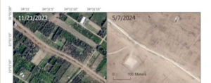
Satellite images show destruction of trees in north Gaza
To address this problem, we mapped the damage to tree crops – mostly olive and citrus trees – in Gaza each month over the course of the war up until September 2024. Together with our colleagues Dimah Habash and Mazin Qumsiyeh, we did this using very high-resolution satellite imagery, detailed enough to focus on individual trees.
We first visually identified tree crops with and without damage to “train” our computer program, or model, so it knew what to look for. We then ran the model on all the satellite data. We also looked over a sample of results ourselves to confirm it was accurate.
Our results showed that between 64% and 70% of all tree crop fields in Gaza had been damaged.