

Buffer zone and control corridor: What the Israeli Army’s entrenchment in Gaza looks like
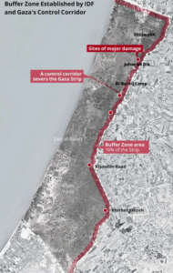
Buffer zone and control corridor
Yarden Michaeli and Avi Scharf write in Haaretz on 28 March 2024:
Without providing many details, Israel is currently pursuing a massive project in the Gaza Strip – the establishment of a buffer zone adjacent to the border fence with Israel. The planned zone will be about one kilometer wide, and upon completion will encompass some 16 percent of the Gaza Strip’s area.
The project involves IDF engineering forces which are operating in the field, significantly expanding the area declared by the IDF as a Palestinian no-go zone before the war. The project is already provoking stark criticism from the international community. Haaretz has learned that a project director has been appointed by the IDF.
This infrastructure project joins another which is already taking shape – the creation of a control corridor, cutting the Gaza Strip into two parts and allowing the IDF to control traffic on strategic roads, which are at the core of negotiations with Hamas. These two projects – the buffer zone and the control corridor – together imply that the IDF is preparing for a long-term presence in the Strip.
In reply to inquiries by Haaretz, the IDF spokesperson chose to use vague terminology, saying that Israeli forces are busy “arranging the obstacle area as part of the implementation of a defense strategy, and in accordance with government instruction.” The IDF’s refusal to release details on the project and the restrictions it imposes on journalists’ entry to the Gaza Strip make it difficult to understand the emerging reality on the ground, including the demolition of numerous civilian structures.
However, hi-resolution satellite images, made by private satellite imaging company Planet Labs, show the emerging buffer zone, and that the IDF had already demolished many structures within it.
Haaretz examined satellite images of the buffer zone from north to south, comparing them to pre-war images, and recognized several epicenters of destruction, including structures razed to the ground, as can be seen in the following images.
Shujaiyeh (2022: Google Earth | 2024: Planet Labs PBC)
It is unknown whether all the structures crossing the line and appearing in the images were demolished as part of the buffer zone project, or due to other war-related causes. According to an informed source, houses are being demolished even a little beyond the one-kilometer line, so as not to allow access to the buffer zone. In several spots, the satellite images indicate demolished buildings at some 1,200 meters from the border fence.
Juhor ad Dik (2022: Google Earth | 2024: Planet Labs PBC)
This neighborhood was 1,100 to 1,500 meters from the border with Israel, near Juhor ad Dik. It’s unclear whether this was part of the buffer zone demolition. (2022: Google Earth | 2024: Planet Labs PBC)
The bright line you see in the first image above is the Netzarim corridor. The Netzarim corridor is a strategic route. According to an IDF source, it is intended to cut the Gaza Strip in two, allowing quick military access inside it, as well as allowing Israel to monitor and control the movement of Palestinians between the northern and southern sectors. The corridor is easily seen in the satellite images. At two points along the corridor, Haaretz recognized what seems to be preparation areas, with flagpoles – some already standing, and one still on the ground as of March 20.
The satellite images indicate that the preparation areas were set up close to two strategic roads – the Salah al-Din Road and the coastal route. At the beginning of the war, following Hamas’ surprise attack on Israeli communities near the Gaza border, the IDF ordered residents of the northern part of the Gaza Strip to evacuate to the south using these two roads. Hundreds of thousands of people escaped south in this way, and the majority of the Gaza Strip’s population is currently huddling together in tent-towns in the south. The issue of their return to the north is at the core of negotiations between Israel and Hamas.
South of the Netzarim corridor, works on the buffer zone adjacent to the border are ongoing. Terrain clearance is being carried using a variety of engineering tools. The one-kilometer strip used to comprise agricultural fields, greenhouses, solar panels and many residential structures. The IDF is now systematically demolishing these structures.
According to the informed source, while the buffer zone will feature earth-dykes and IDF forces will go in and out of it, there are currently no plans to set up any permanent military posts inside the zone. Control is intended to be achieved through the use of fire and monitoring from within Israel. The source also explained that the logic behind the new strategy is strict enforcement – IDF will allow no one to come close, and will shoot at whoever crosses the line.
Al-Bureij Camp (2022: Google Earth | 2024: Planet Labs PBC)
In his “day after” plan, released in February, prime minister Benjamin Netanyahu noted that “the buffer zone established in the Gaza Strip in the area bordering Israel will exist as long as there is a security need for it.” However, Netanyahu provided no further details in the document, and speaks very little on the subject. One of Hamas’ main demands in the negotiations is a complete Israeli withdrawal from the Gaza Strip, and at this stage there is no open discussion of the nature of any planned Israeli presence in the buffer zone.
Israel updated neighboring Arab states on its intention to set up a buffer zone within Gaza as early as last December, as reported by Reuters, quoting sources in the region. In reply to Haaretz inquiries on the subject, the IDF said that as part of its operations in the war, “the IDF is committed to fulfill its mission, to provide security to residents of the Gaza Envelope and to all citizens of Israel, including the implementation of a defense strategy that will prevent terror attacks from within the Strip.”
“As part of the implementation of the defense strategy, and in accordance with government instructions, the IDF is destroying terrorist infrastructure, strengthening communities’ defense elements, maintains widespread IDF presence in the area and is taking a number of steps, including organizing the obstacle zone. These steps are necessary to prevent Hamas and other terrorist organizations from operating in the area. All this, in compliance with international law, and with the understanding that the obstacle zone is critical to the enemy’s ability to carry out offensive terrorist activity.” It further said that “as part of the land maneuver, the IDF maintains security deployment in the area in accordance with evaluations of the situation.”
Kissufim Road area
The idea of a buffer zone is not new, and even before the war Israel imposed a buffer zone along the border. In the past, Gazans who came within 300 meters of the security fence were in danger of coming under fire. According to the UN Office for the Coordination of Humanitarian Affairs (OCHA), even areas lying hundreds of meters beyond this range, were considered unsafe for Gazans, preventing agricultural activity in the area.
According to human rights organization Gisha, before the war, farmers were permitted to come as close as 100 meters from the fence, and after 2014 Israel began to spray herbicides on areas close to the fence, damaging agriculture in the vicinity. Terrain clearance work currently underway in the buffer zone includes the uprooting of trees.
During Hamas’ October 7 terrorist attack, Nukhba forces quickly crossed the previous buffer zone, broke open the fence at several spots, and so were able to enter Gaza border communities, murdering 1,200 people and abducting another 240. In the war, Hamas terrorists use the civilian population in Gaza as a human shield and take cover in underground tunnels.
Khirbet Khizeh (2022: Google Earth | 2024: Planet Labs PBC)
The buffer zone project is raising international criticism, including claims that it may be construed as being in violation of the Geneva convention and thus a war crime. Thus, the UN High Commissioner for Human Rights, Volker Türk, last month said that IDF forces are “reportedly destroying all buildings in the Gaza Strip that are within a kilometer of the Israel-Gaza fence, clearing the area with the objective of creating a buffer zone.” The High Commissioner added, “Israel has not provided clear reasons for such extensive destruction of civilian infrastructure. I remind the authorities that forcible transfer of civilians may constitute a war crime.”
The IDF did not respond to Haaretz’s inquiry as to the number of structures demolished so far as part of the setup of the buffer zone, nor as to the number of structures expected to be demolished by the time the setup is completed.
The pre-war satellite images presented in this report are from 2022, from Google Earth. Additional satellite images from October 2023 indicate that the destruction happened at a later date.
The text of this article is reproduced in its entirety; satellite images link