

Fact sheet on Ariel

30 August 2010: Ariel settlement fact sheet
1. Ariel is an Israeli settlement in the Salfit District in the central West Bank, some 16.5 kilometers east of the Green Line, with a population of 16,800 (at the end of 2009). It was founded in 1978 on land that was seized under the false pretext of imperative military needs and on land that was declared state land, including cultivated farmland of villages in the district and on rocky land the villagers used for grazing their flocks. The state’s declaration of state land was made in breach of the right to due process and relied on a distorted interpretation of the binding legislation in the West Bank. The settlement’s municipal area contains many enclaves of privately-owned Palestinian land, whose owners are not allowed access to them (see map).
2. Ariel was established in the heart of Salfit District, in a way that blocks the urban development of the regional town of Salfit. Israel does not allow lands to be transferred from the Area C category (lands that are under Israeli control and comprise 60 percent of the West Bank) to the Area A and Area B categories, which are under Palestinian control, and thus prevents future development of Salfit.
3. The Separation Barrier built around Ariel created a wedge that separates seven villages north of it (Hares, Kifl Hares, Qira, Marda, Jamma’in, Zeita-Jamma’in, and Deir Istiya), which are home to some 25,000 Palestinians, from the district seat, Salfit (10,000 residents), where the villagers receive a variety of services.
4. Israel has blocked Palestinian entry to Salfit from the north via a road branching off the Trans-Samarian Highway that also serves as the main access road to Ariel. As a result, Palestinians must travel a long way, via the Tapuah junction and the villages Yasuf and Iskaka, to the eastern entrance to Salfit. What was once a five-minute trip now takes 30-40 minutes, sometimes more.
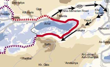
Map of the long travel route between villages north of Ariel and their regional town, Salfit.
5. The prolonged neglect of treatment of Ariel’s wastewater, due to the malfunctioning of the treatment facility inside the settlement, has led several times to pollution of Salfit’s central water-pumping facility. The flow of Ariel’s waste has already damaged the flora and fauna in Wadi al-Matawi, between Salfit and Ariel.
6. Israel prevents the building of a wastewater-treatment facility in the town of Salfit, although funding has been found for it, and conditions approval on Palestinian willingness to use the facility to treat Ariel wastewater as well.
7. According to a 2007 report of the Finance Ministry’s accountant general, Ariel receives higher per capita financial support than any other Israeli authority. The per capita allocation in Ariel (NIS 9,035 a year) was 7.9 times higher than the average per capita allocation for municipalities in Israel (NIS 1,200 a year), even though Ariel belongs to a relatively high socioeconomic cluster (6).